RC01 - Lower Cachi - Puente Allccomachay
Site: RC01 - Lower Cachi - Puente Allccomachay
GPS: S12°843874, W74°328924. Elevation: 2158m asl.
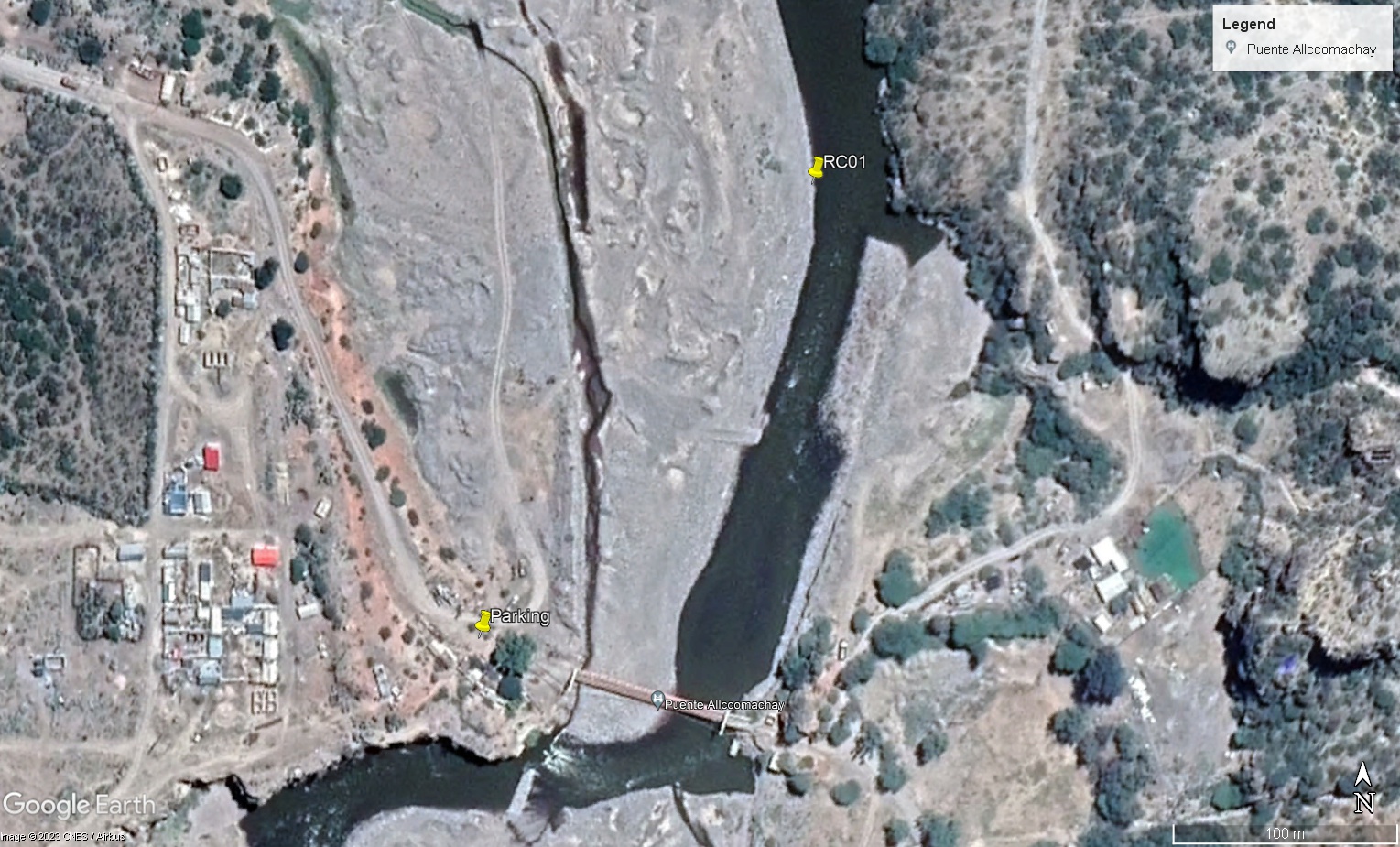 Site RC01 - Study site location: below Puente Allccomachay
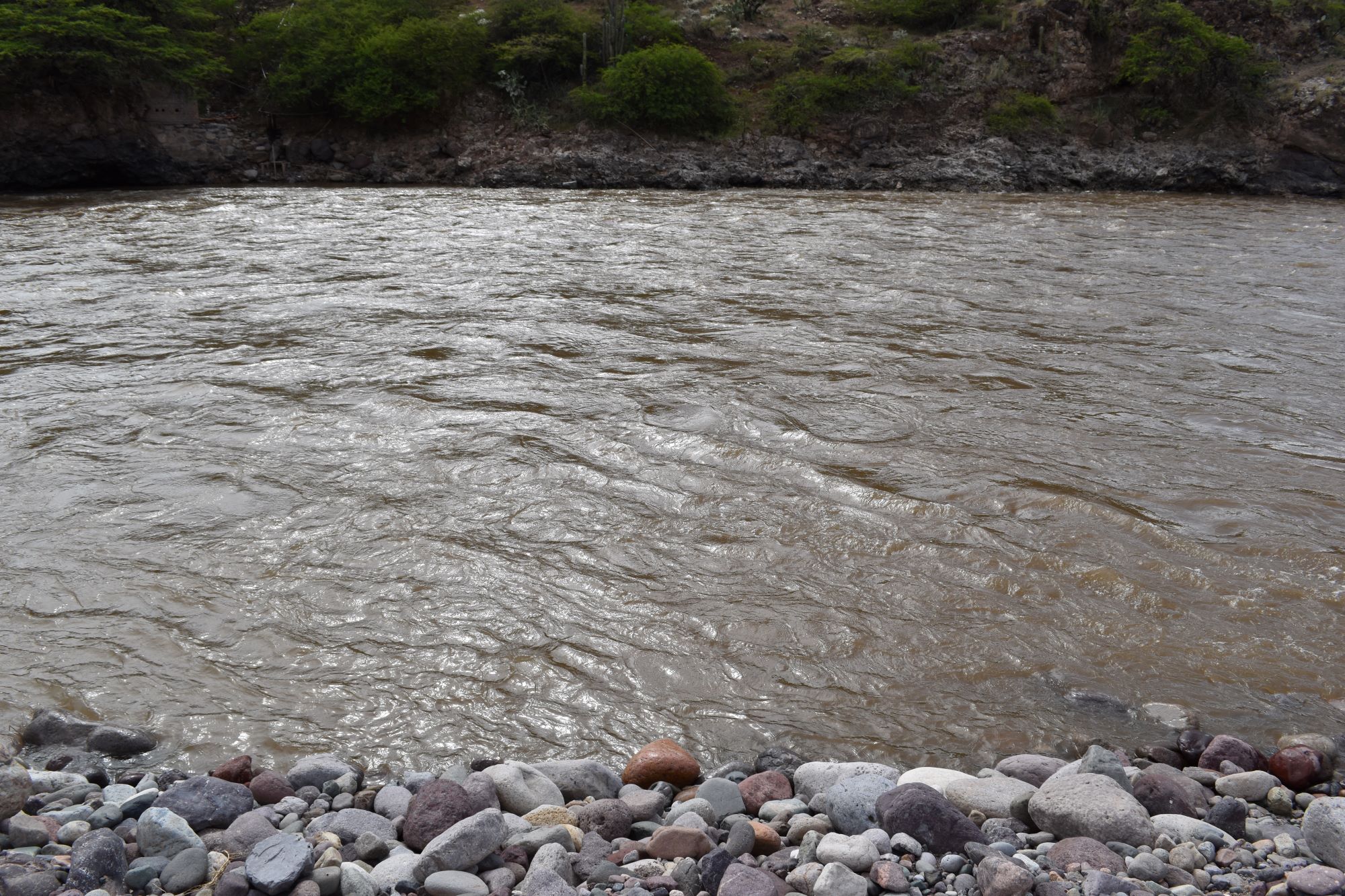 Site RC01 - the study site. (March 2023) (John Forrest)
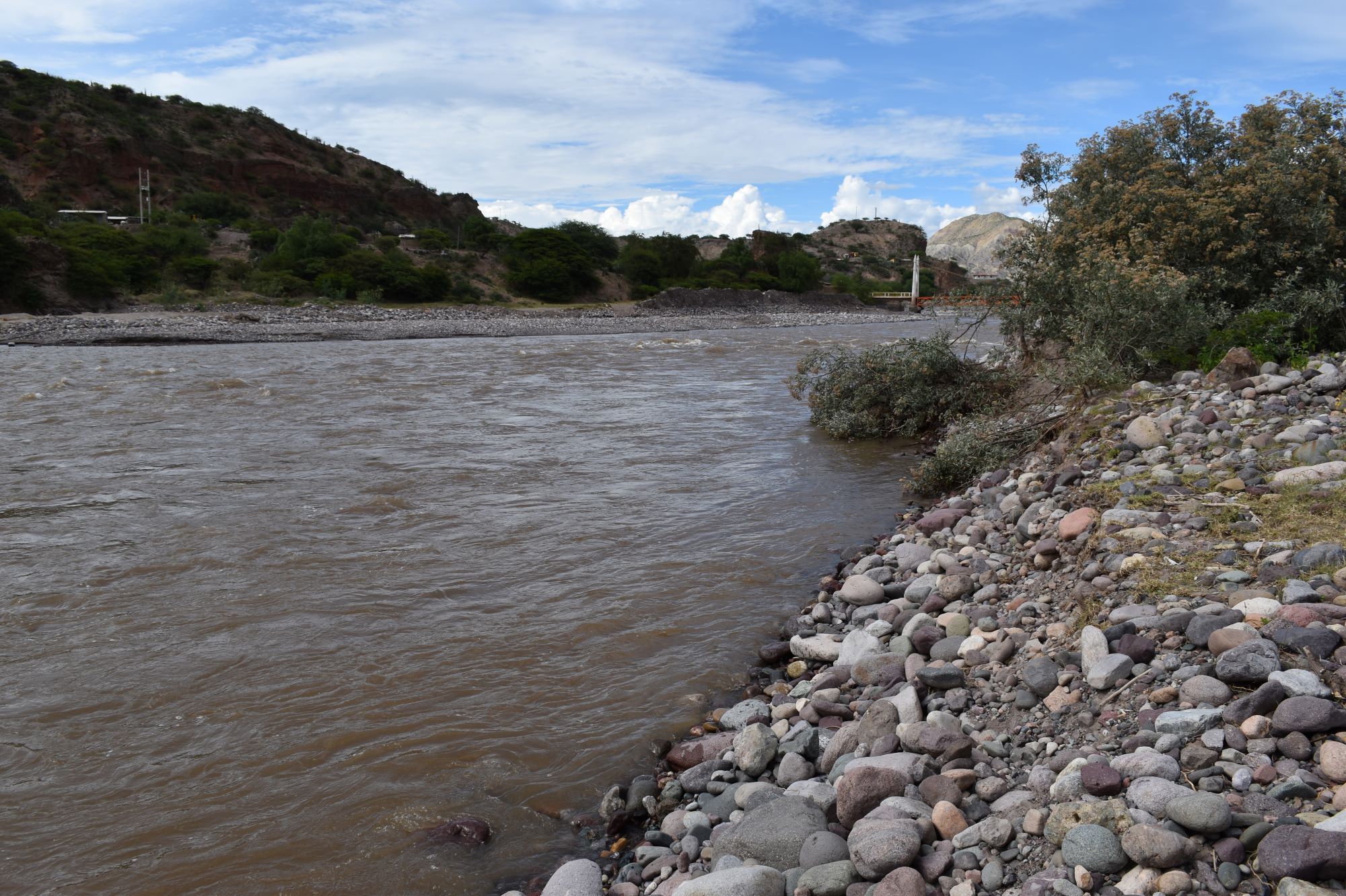 Site RC01 - View upstream. (March 2023) (John Forrest)
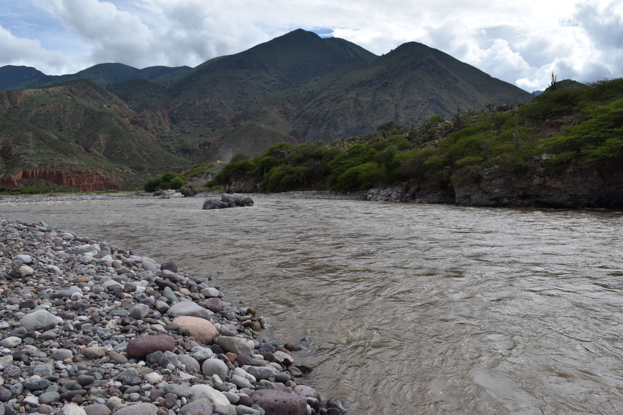 Site RC01 - View downstream. (March 2023) (John Forrest)
Site description
RC01 is located in the final section of the river Cachi just above its confluence with the river Mantaro. The valley is wider at this point and the flood-plain is up to 200 metres across. The study site is situated on the left bank of the river Cachi about 200 metres downstream from the new Allccomachay bridge / 100 metres below the old bridge. The precise position is opposite a large rock outcrop on the steep right bank and just below the confluence with a small stream entering the Rio Cachi on the right bank. The Rio Cachi normally consists of a single channel at this point, whereas upstream and sometimes downstream from this point the channel is braided.
The study site is located on extensive river deposits so its precise position may vary on a seasonal basis with the shifting of the deposits. A rise and fall in the river level may also impact upon the precise location of the site.
Between June and November 2023 gravel extraction operations commenced just upriver from the old bridge and study site.
It may be possible to drive down on to the river deposits to access the site. If this is not possible, park in front of the housing at the old bridge entrance on the north bank and walk down.
Descripción del sitio
RC01 se encuentra en el tramo final del Río Cachi, justo rio arriba de su confluencia con el río Mantaro. El valle es más amplio en este punto y la llanura alluvial tiene hasta 150 metros de ancho. El sitio de estudio está situado en la margen izquierda del Río Cachi a unos 200 metros rio abajo del puente Allcomachay nuevo / 100 metros rio abajo del puente antiguo. La posición exacta es frente a un a roca grande en la orilla derecha y justo debajo de la confluencia con un pequeño arroyo que entra en el Río Cachi por la orilla derecha porque normalmente hay un solo canal en este punto, mientras que por encima del puente y a veces rio abajo el canal está trenzado.
El sitio de muestreo está situado sobre extensos depósitos fluviales, por lo que su posición exacta puede variar estacionalmente con el desplazamiento de los depósitos. Las subidas y bajadas del nivel del río también pueden influir en la ubicación exacta del lugar.
Entre junio y noviembre de 2023 comenzaron las operaciones de extracción de piedritas y arena justo río arriba del antiguo puente y del sitio de muestreo
Puede que sea posible bajar con el auto hasta los depósitos fluviales para acceder el sitio. Si no es posible, se puede aparcar delante de las viviendas en la entrada del puente antiguo por la orilla norte y bajar andando.
Data Analysis
Discharge at site RC01 is highly responsive to precipitation in the river Cachi catchment, in particular the extensive high altitude upper Cachi area above Ayacucho but also the Huancavelica sierras that drain into the lower river Cachi. The tributaries flowing westwards from the Sierra Razuhuillca into the river Cachi do not make a major contribution to its discharge.
The 2023 wet season was relatively dry and this is reflected in the lower discharge figures in all three months when the river was visited. The highest figure in 2024 was recorded in March at the height of the wet season. 2024 was a much wetter year and the rains lasted for longer, which is reflected in the June 2024 data. By November 2024 significant rains had not yet started at higher altitudes which was reflected in the low discharge measurement. In February 2025 the highest discharge to date was recorded following several days of heavy rain which remained reflected in the June 2025 figure while in November 2025 the figure was low as significant rains higher up the catchment were yet to arrive.
The higher discharge at RC01 compared to RC02 results more from drainage eastwards from the Huancavelica sierras than from drainage westwards from Sierra Razuhuillca. The west flank of the Sierra Razuhuillca lies in a partial rain shadow which is not the case for the east flank of the Huancavelica sierras.
With a higher discharge it would appear that the pH, conductivity and alkalinity measurements are all lower.
Water quality in the river Cachi appeared to be most influenced by precipitation levels far away in the upper Cachi catchment, contamination entering the river from the city of Huamanga (Ayacucho) and the geology of the upper Cachi valley which includes volcanics.
Análisis de datos
La descarga en el sitio RC01 es altamente sensible a la precipitación en la cuenca del Río Cachi, en particular la extensa zona de gran altitud del alto Cachi por encima de Ayacucho, pero también las sierras de Huancavelica que drenan en el bajo Río Cachi. Los afluentes que fluyen hacia el oeste desde la Sierra Razuhuillca hacia el Río Cachi no contribuyen de forma importante a su descarga.
La estación húmeda de 2023 fue relativamente seca y esto se refleja en las cifras de caudal más bajas en los tres meses en que se visitó el río. La cifra más alta de 2024 se registró en marzo, en plena estación húmeda. 2024 fue un año mucho más húmedo y las lluvias duraron más tiempo, lo que se refleja en los datos de junio de 2024. En noviembre de 2024 aún no habían comenzado las lluvias significativas a mayor altitud, lo que se reflejó en la baja medición de la descarga. EEn febrero de 2025 se registró el mayor caudal hasta la fecha tras varios días de fuertes lluvias, lo que se reflejó en la cifra de junio de 2025, mientras que en noviembre de 2025 la cifra fue baja, ya que aún no se habían producido lluvias significativas en las zonas más altas de la cuenca.
La descarga más alta en RC01 comparada con RC02 resulta más del drenaje hacia el este de las sierras de Huancavelica que del drenaje hacia el oeste de la Sierra Razuhuillca. El flanco oeste de la Sierra Razuhuillca se encuentra en sombra parcial de lluvia, lo que no es el caso del flanco este de las sierras de Huancavelica.
Con una descarga mayor, parece que las mediciones de pH, alcalinidad y conductividad son todas más bajas.
La calidad del agua del río Cachi parecía estar más influenciada por los niveles de precipitación en la lejana cuenca alta del Cachi, la contaminación que llegaba al río desde la ciudad de Huamanga (Ayacucho) y la geología del valle alto del Cachi, que incluye volcanes.
River & Water Quality data / Datos fluviales y de calidad del agua
The following river and water quality data was collected from this site:
En este lugar se recogieron los siguientes datos fluviales y de calidad del agua:
| Site / Sitio: RC01 | March / marzo 2023 | June / junio 2023 | November / noviembre 2023 | March / marzo 2024 | June / junio 2024 | November / noviembre 2024 | February / febrero 2025 | June / junio 2025 | November / noviembre 2025 |
|---|---|---|---|---|---|---|---|---|---|
| Season / Temporada: | Austral Summer / Verano | Austral Winter / Invierno | Austral Winter / Invierno | Austral Summer / Verano | Austral Winter / Invierno | Austral Winter / Invierno | Austral Summer / Verano | Austral Winter / Invierno | Austral Winter / Invierno |
| Date / Fecha: | 14.3.23 | 17.6.23 | 18.11.23 | 17.3.24 | 19.6.24 | 19.11.24 | 18.2.25 | 24.6.25 | 25.11.25 |
| Time / Hora: | 8.15 | 8.30 | 8.30 | 9.00 | 8.30 | 8.30 | 8.45 | 8.30 | 8.30 |
| Width / Ancho (m) | 42.7 | 34.75 | 49.0 | 107.0 | 64.0 | 65.0 | 77.0 | 24.0 | 30.0 |
| Depth / Profundidad (Av.) (m) | 1.10 | 0.35 | 0.42 | 0.59 | 0.47 | 0.27 | 0.97 | 0.83 | 0.37 |
| CSA / Area traversal (Av.) (m²) | 46.97 | 12.16 | 20.776 | 59.92 | 30.08 | 18.55 | 74.69 | 19.20 | 11.10 |
| Velocity / Velocidad (Av.) (m/s) | 0.75 | 0.38 | 0.63 | 0.67 | 0.78 | 0.52 | 0.702 | 0.450 | 0.503 |
| Discharge / Caudal (Av.) (m³/s) | 35.228 | 4.622 | 13.089 | 40.146 | 23.432 | 9.090 | 52.432 | 8.928 | 4.740 |
| Riverbed sediment / Sedimentos | Mainly boulders / Mas rocas | Mainly sand / Mas arena | Mainly boulders / Mas rocas | Mainly pebbles & cobbles / Mas piedritas y piedras | Mainly pebbles & cobbles / Mas piedritas y piedras | A mix: few rocks / Una mezcla – pocas rocas | A mix: much sand / Una mezcla – mucho arena | A mix: many boulders / Una mezcla: muchas rocas | Mainly boulders - some sand / Mas rocas - algo de arena |
| Temperature (Atmospheric) (°C) | 18.0 | 18.0 | 28.0 | 21.6 | 17.0 | 25.3 | 17.6 | 18.3 | 29.8 |
| Temperature (Water / Agua) (°C) | 15.52 | 14.62 | 19.66 | 16.70 | 16.49 | 17.93 | 15.62 | 13.75 | 19.45 |
| Atmospheric pressure / presión (mbar) | 820.6 | 813.2 | 822.3 | 815.9 | 806.2 | 815.9 | 815.2 | 815.4 | 807.2 |
| Dissolved oxygen / Oxigeno disuelto (ppm) (MP)* | 11.89 | 6.01 | 3.12 | 3.44 | 4.55 | 4.66 | 3.92 | 3.42 | |
| Dissolved oxygen / Oxigeno disuelto (%) (MP)* | 137.6 | 76.78 | 37.8 | 42.0 | 74.0 | 72.5 | 58.7 | 43.3 | |
| pH | 8.33 | 8.57 | 8.28 | 8.30 | 8.16 | 8.39 | 7.64 | 8.27 | 8.42 |
| Conductivity / Conductividad (µS/cm) | 250 | 639 | 601 | 275 | 583 | 495 | 305 | 999 | 702 |
| Total Dissolved Solids (TDS / SDT) (ppm) | 125 | 320 | 300 | 137 | 292 | 286 | 153 | 500 | 351 |
| ORP (mV) | 233.8 | 85.8 | 34.53 | 38.48 | 97.6 | 23.1 | 88.7 | 25.6 | 89.4 |
| Turbidity / Turbidez | Turbid: light brown / marron ligero | Clear / Transparente | Turbid: Chocolate / Chocolate | Turbid: light brown / marron ligero | Turbid: grey brown / gris marron | Turbid: light brown / marron ligero | Turbid: light brown / marron ligero | Turbid: green / blue / brown | Light brown / marron ligero |
| Alkalinity/Alkalinidad (Titración) (mg/l CaCO₃) (1.6N) | 91 | 183 | 159 | 131 | 139 | 142 | 102 | 114 | 165 |
| Alkalinity Field Tester (Hanna) (ppm CaCO₃) | 74 | 154 | 135 | 87 | 148 | 126 | 62 | 136 | 148 |
| *Also refer to MT DO results post-2023 / Consulte también los resultados de MT DO posteriores a 2023. |