RC02 - Upper Cachi - Cangari
RC02 - Upper Cachi - Cangari
GPS: S12°99964, W74°285016. Elevation: 2335m asl.
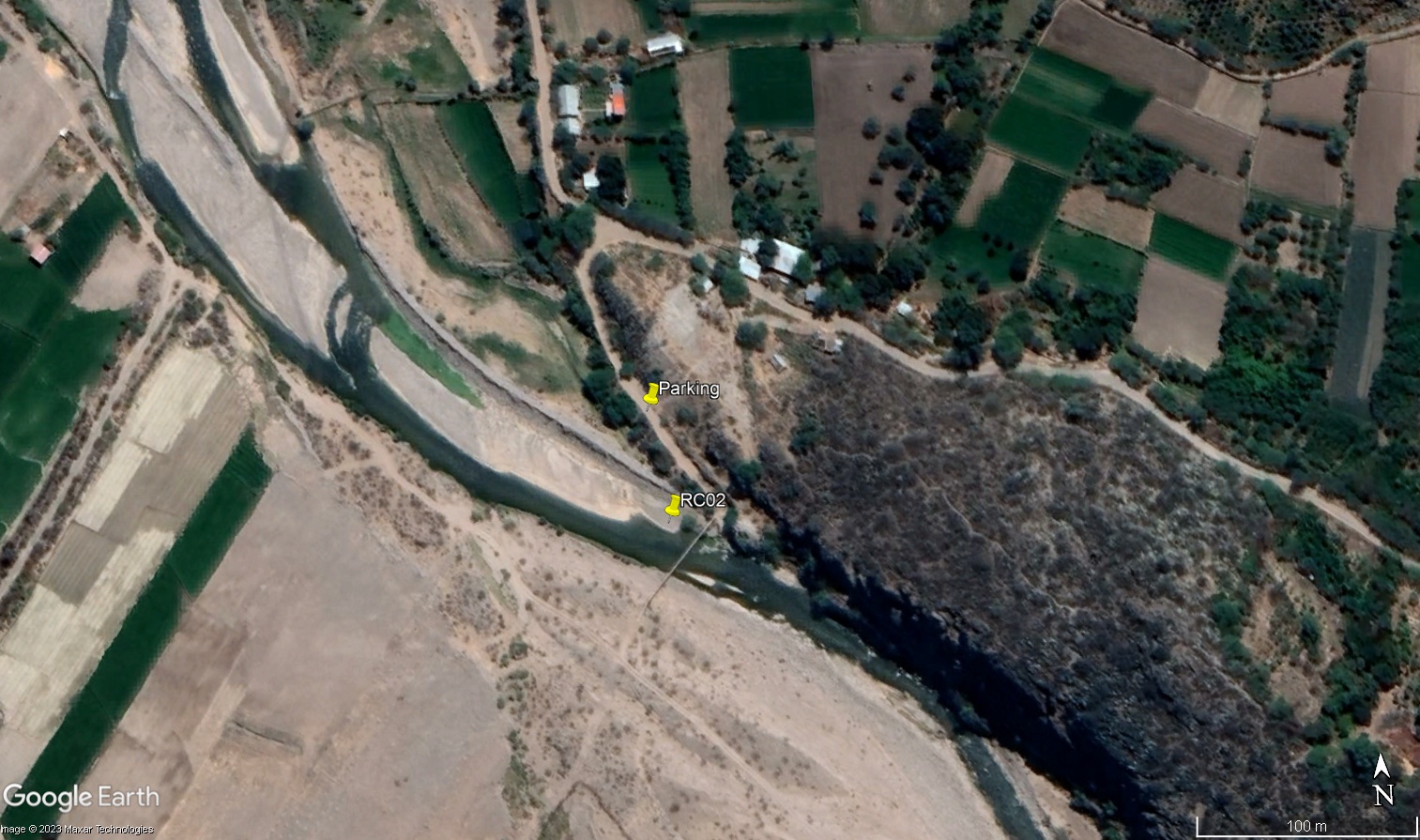 Site RC02 - Study site location: Puente Cangari
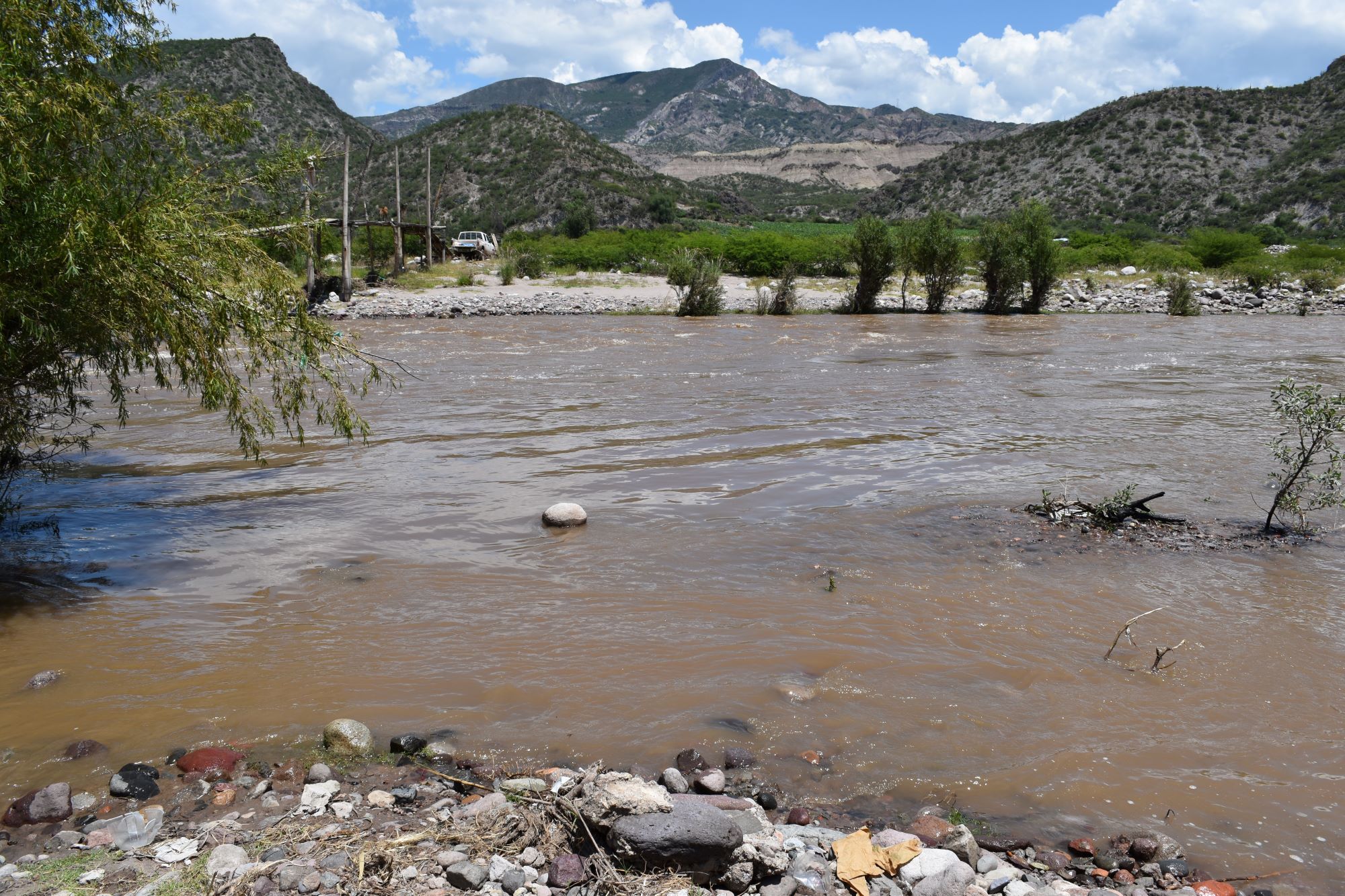 Site RC02 - the study site. (March 2023) (John Forrest)
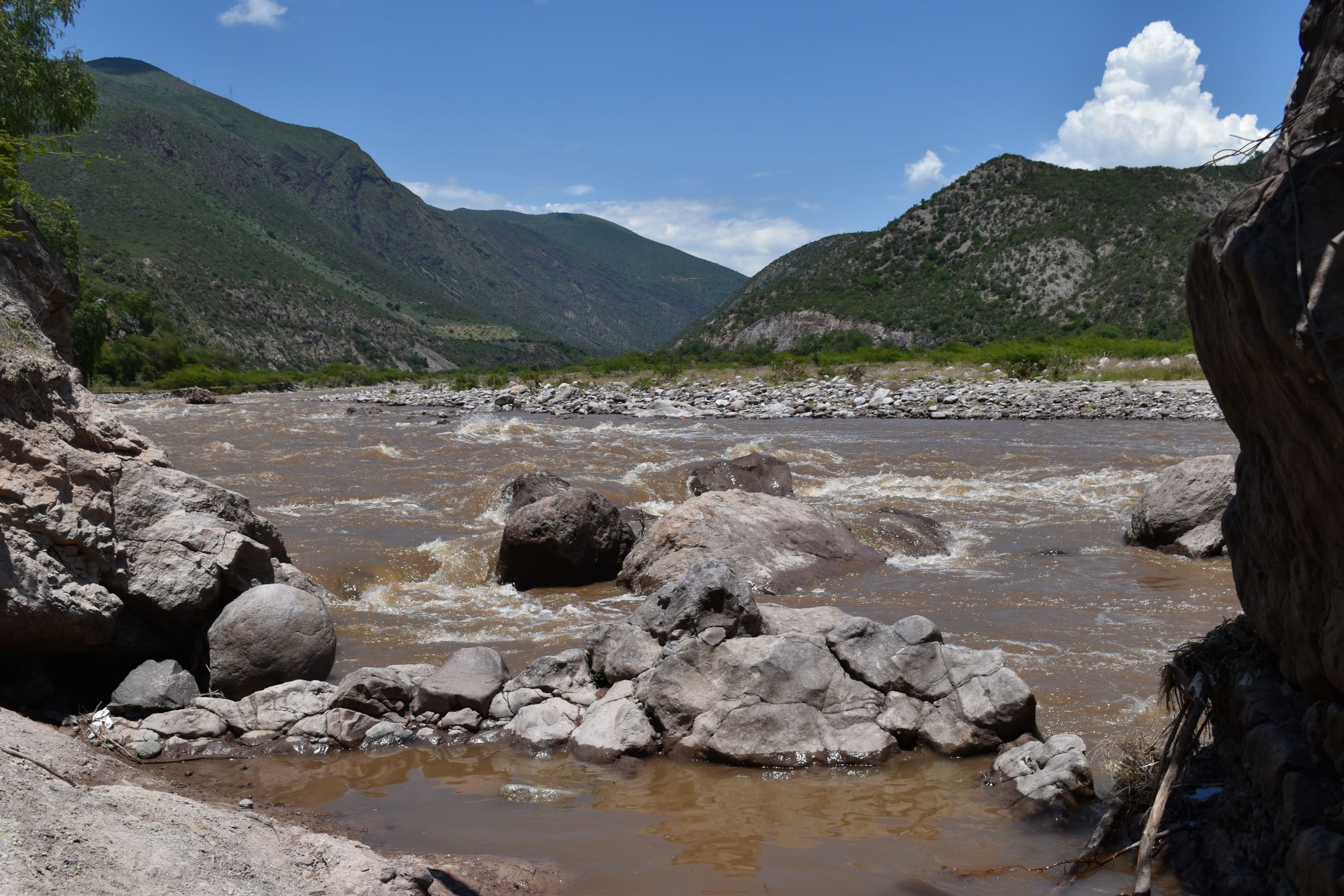 Site RC02 - View upstream. (March 2023) (John Forrest)
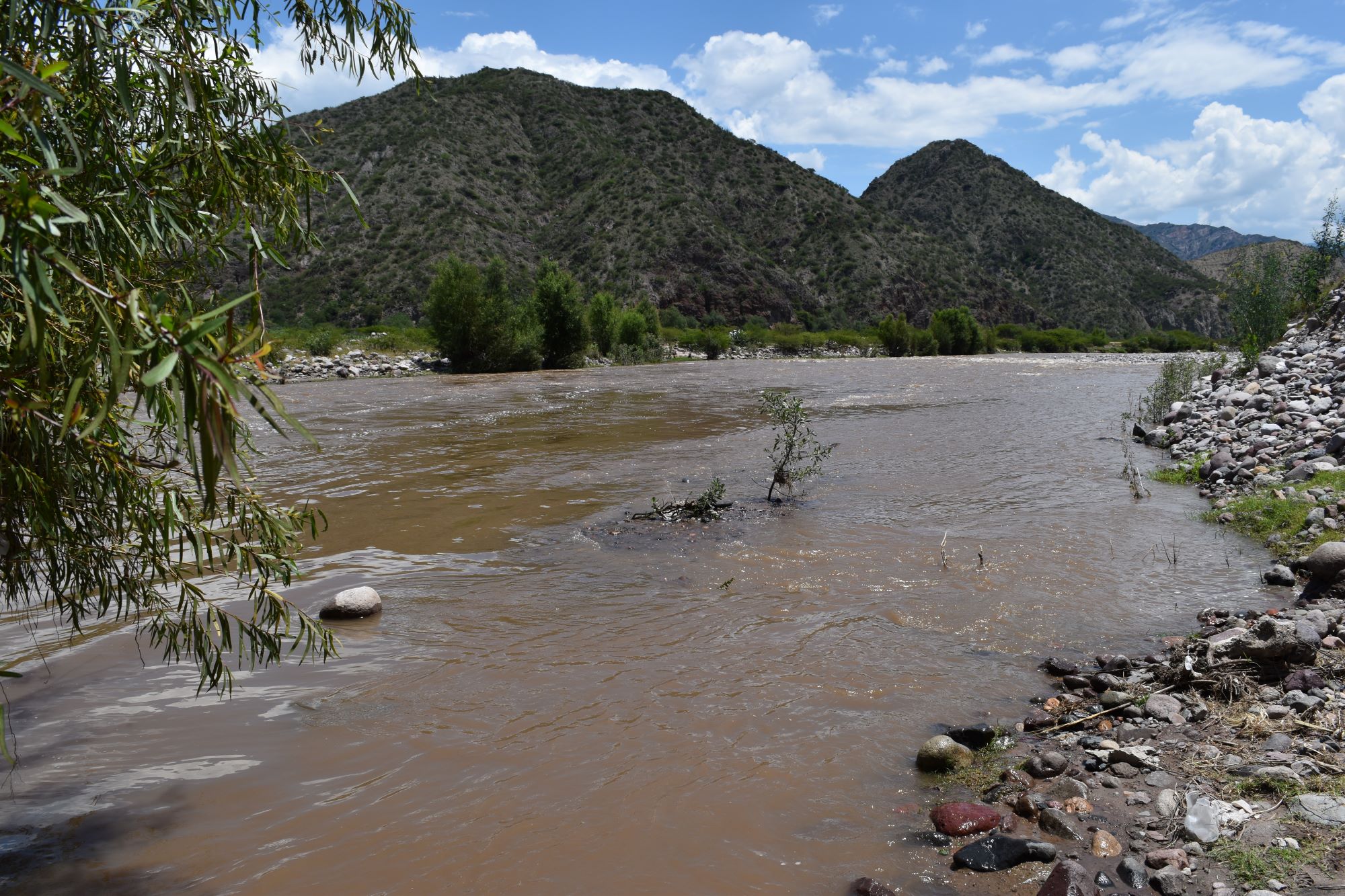 Site RC02 - View downstream. (March 2023) (John Forrest)
Site description
RC02 is located in the Cachi valley beneath the large Allcohuillca hill, upstream from its confluence with the River Huamanguilla-Iguian but well below the point where water is extracted in a large canal to irrigate the lower Huanta area. The river emerges from a narrower section of the valley, with both the valley and the channel becoming wider at this point.
The study site is situated where a footbridge over the river. Measurements and samples are taken from both sides of the river just upstream on the right bank from a large rock on which the bridge is supported and just upstream from the bridge on the left bank. The river flows in a single channel at this point.
The site is located on river deposits so its precise position may vary on a seasonal basis with the shifting of the deposits. If it is possible to cross the bridge, 2-3 sets of data should be recorded on one side of the river and 2-3 sets on the other side. A rise and fall in the river level may also impact upon the precise location of the site.
It is possible to park on the road running down to the footbridge which is located about 2kms north of Cangari.
Descripción del sitio
La RC02 se encuentra en el valle de Cachi, bajo el gran cerro Allcohuillca, aguas arriba de su confluencia con el Río Huamanguilla-Iguian, pero muy por debajo del punto donde se extrae el agua en un gran canal para regar la zona baja de Huanta. El río Cachi emerge de una sección más angosta del valle, y tanto el valle como el canal se vuelven más anchos en este punto.
El lugar de estudio está situado justo a una puente peatonal sobre el río. Las mediciones y las muestras se toman a ambos lados del río, justo rio arriba, en la orilla derecha, de una gran roca sobre la que se apoya el puente, y justo rio arriba del puente, en la orilla izquierda. En este punto, el río fluye en un único cauce.
El sitio está situado sobre depósitos fluviales, por lo que su posición exacta puede variar estacionalmente con el desplazamiento de los depósitos. Si es posible cruzar el puente, deben registrarse 2 ó 3 series de datos a un lado del río y 2 ó 3 series al otro lado. Las subidas y bajadas del nivel del río también pueden influir en la ubicación exacta del sitio.
Es posible aparcar en la carretera que baja hasta la pasarela, situada a unos 2 kms al norte de Cangari.
Data analysis
Discharge at site RC02 is highly responsive to precipitation, in particular the extensive high altitude upper river Cachi area above Ayacucho.
The 2023 wet season was relatively dry but rains coincided with the visit to RC02 in March. Subsequently, very little rain then fell for many months greatly reducing the discharge in June and November.
2024 was a wetter year and the rains lasted for longer, which is also reflected in the June data. By November the rains had just started to arrive again to higher areas so the discharge was already beginning to increase.
In February 2025 the highest discharge to date was recorded following several days of heavy rain but this had greatly reduced by June and the November figure was very low due to the lack of significant rainfall yet higher up in the catchment.
With a higher discharge it would appear that the pH, alkalinity and conductivity measurements are all lower.
Análisis de datos
La descarga en el sitio RC02 es altamente sensible a la precipitación, en particular en la extensa área del Rio Cachi superior sobre Ayacucho.
La estación húmeda de 2023 fue relativamente seca pero las lluvias coincidieron con la visita a RC02 en marzo. Posteriormente, llovió muy poco durante muchos meses, lo que redujo considerablemente la descarga en junio y noviembre.
2024 fue un año más húmedo y las lluvias duraron más tiempo, lo que también se refleja en los datos de junio. En noviembre, las lluvias acababan de empezar a llegar de nuevo a las zonas altas, por lo que el desembalse ya empezaba a aumentar.
En febrero de 2025 se registró el mayor caudal hasta la fecha tras varios días de fuertes lluvias, pero este se había reducido considerablemente en junio y la cifra de noviembre fue muy baja debido a la falta de precipitaciones significativas en las zonas más altas de la cuenca.
Con una descarga mayor, parece que las mediciones de pH, alcalinidad y conductividad son todas más bajas.
River & Water quality data / Datos fluviales y de calidad del agua
The following river and water quality data was collected from this site:
En este lugar se recogieron los siguientes datos fluviales y de calidad del agua:
| Site / Sitio: RC02 | March / marzo 2023 | June / junio 2023 | November / noviembre 2023 | March / marzo 2024 | June / junio 2024 | November / noviembre 2024 | February / febrero 2025 | June / junio 2025 | November / noviembre 2025 |
|---|---|---|---|---|---|---|---|---|---|
| Season / Temporada: | Austral Summer / Verano | Austral Winter / Invierno | Austral Winter / Invierno | Austral Summer / Verano | Austral Winter / Invierno | Austral Winter / Invierno | Austral Summer / Verano | Austral Winter / Invierno | Austral Winter / Invierno |
| Date / Fecha: | 20.3.23 | 20.6.23 | 23.11.23 | 20.3.24 | 23.6.24 | 24.11.24 | 21.2.25 | 27.6.25 | 28.11.25 |
| Time / Hora: | 11.30 | 12.00 | 11.15 | 10.00 | 11.00 | 11.45 | 11.00 | 11.00 | 11.15 |
| Width / Ancho (m) | 29.5 | 23.1 | 19.4 | 36.0 | 19.0 | 20.0 | 34.6 | 13.00 | 13.72 |
| Depth / Profundidad (Av.) (m) | 0.92 | 0.34 | 0.26 | 0.65 | 0.61 | 0.61 | 1.02 | 0.59 | 0.45 |
| CSA / Area traversal (Av.) (m²) | 27.25 | 7.85 | 5.122 | 23.40 | 11.59 | 12.20 | 35.29 | 8.97 | 6.17 |
| Velocity / Velocidad (Av.) (m/s) | 1.240 | 0.366 | 0.383 | 1.090 | 0.724 | 0.639 | 1.090 | 0.713 | 0.503 |
| Discharge / Caudal (Av.) (m³/s) | 33.845 | 2.906 | 1.962 | 25.506 | 8.389 | 7.796 | 38.468 | 6.400 | 3.106 |
| Riverbed sediment / Sedimentos | Boulders & cobbles / Rocas y piedras | Sand & pebbles / Arena y piedritas | Pebbles & cobbles / Piedras y piedritas | Boulders & cobbles / Rocas y piedras | All sizes / Todos tamaños | All sizes / Todos tamaños | All sizes / Todos tamaños | A mix: many boulders / Una mezcla: muchas rocas | All sizes / Todos tamaños |
| Temperature (Atmospheric) (°C) | 27.2 | 22.0 | 29.7 | 20.6 | 21.2 | 22.7 | 21.9 | 22.9 | 25.2 |
| Temperature (Water / Agua) (°C) | 17.06 | 17.18 | 23.35 | 15.53 | 15.89 | 20.89 | 15.39 | 15.97 | 22.20 |
| Atmospheric pressure / presión (mbar) | 804.2 | 804.2 | 809.3 | 801.9 | 796.8 | 803.1 | 804.3 | 804.3 | 793.5 |
| Dissolved oxygen / Oxigeno disuelto (ppm) (MP)* | 7.89 | 10.90 | 9.88 | 3.65 | 4.67 | 3.97 | 4.94 | 4.71 | 3.66 |
| Dissolved oxygen / Oxigeno disuelto (%) (MP)* | 100.4 | 138.4 | 140.7 | 58.7 | 57.3 | 71.2 | 79.0 | 75.9 | 51.5 |
| pH | 8.05 | 8.67 | 9.24 | 8.07 | 8.26 | 8.13 | 7.78 | 7.95 | 8.09 |
| Conductivity / Conductividad (µS/cm) | 158 | 551 | 594 | 196 | 480 | 562 | 261 | 919 | 553 |
| Total Dissolved Solids (TDS / SDT) (ppm) | 79 | 279 | 297 | 98 | 238 | 281 | 130 | 460 | 277 |
| ORP (mV) | 230.5 | 169.3 | 163.4 | 84.2 | 84.6 | 120.2 | 153.1 | 84.4 | 98.1 |
| Turbidity / Turbidez | Turbid: light brown / marron ligero | Clear / Transparente | V.slightly turbid / un poco turbidez | Turbid: light brown / marron ligero | Turbid: slightly green & brown / poco verde y marron | Turbid: light brown / marron ligero | Turbid: light brown / marron ligero | Clear: slightly green / Transparente: un poco verde | Turbid: light brown / marron ligero |
| Alkalinity/Alkalinidad (Titración) (mg/l CaCO₃)(1.6N) | 56 | 292 | 178 | 65 | 133 | 111 | 65 | 128 | 133 |
| Alkalinity Field Tester (Hanna) (ppm CaCO₃) | 38 | 142 | 164 | 34 | 114 | 129 | 47 | 108 | 130 |
| *Also refer to MT DO results post-2023 / Consulte también los resultados de MT DO posteriores a 2023. |